Don't miss what's happening in Atascocita
People on Atascocita.com are the first to know.
Go to top of page
Close
 
Close
Back

Eye on the Tropics

Eye on the Tropics

12»
« Back
This discussion has been locked.
Message Menu
by: Andi7 Active Indicator LED Icon 6 OP 
~ 3 years, 6 mos ago   Jun 30, '21 1:32pm  
Eye on the Tropics
 
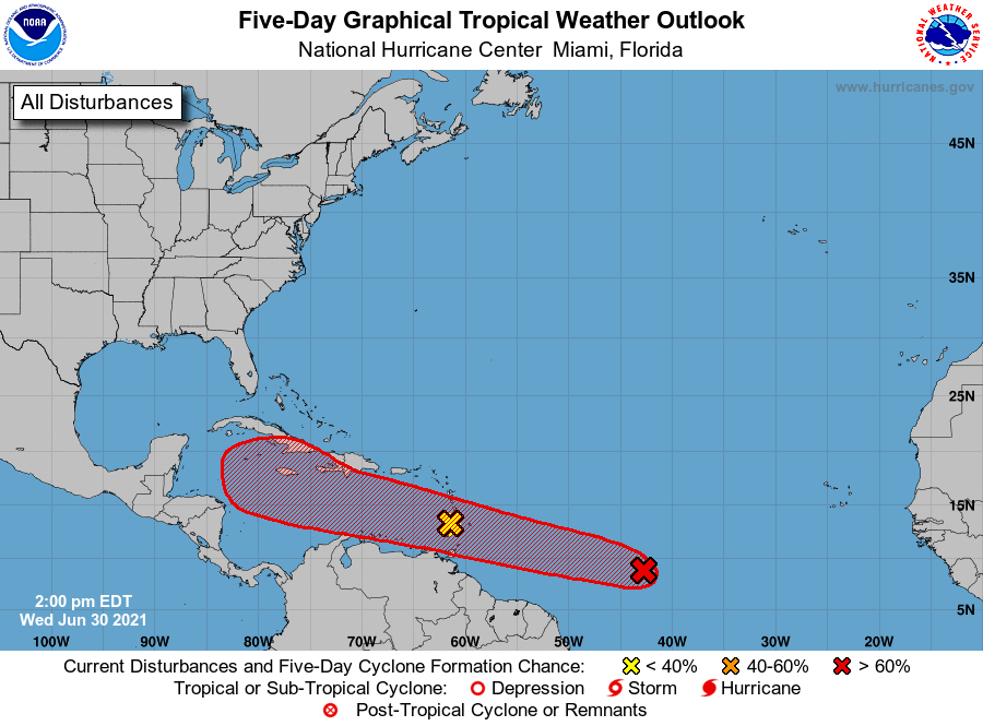
This morning, the National Hurricane Center has upgraded its chance of becoming a tropical storm or depression within the next five days to 80 percent.
 
Loading Image...
 
The most likely scenario remains that this system eventually succumbs to a hostile environment in the Caribbean Sea this weekend, but we can't rule out something making it into the Gulf of Mexico next week.
What are your thoughts? Log in or sign up to comment
Replies:
Message Menu
babypineapple Active Indicator LED Icon 5
~ 3 years, 6 mos ago   Jun 30, '21 1:35pm  
@Andi7 : Does this mean I get to work from home now? Emoticon
Message Menu
CelticStorm Active Indicator LED Icon 6
~ 3 years, 6 mos ago   Jun 30, '21 2:17pm  
I'll be surprised if either of them become anything nearly a problem for us. The back one has the best chance which is still slim.
 
Excuse me while I find some wood to knock on before posting!!!
Message Menu
Cbear Active Indicator LED Icon 4
~ 3 years, 6 mos ago   Jun 30, '21 2:24pm  
@Andi7 : Actually, I just checked again and now it's at 90%!!!!!!!!!!!!!!!!!!!!!!
Message Menu
Weathergirl5 Active Indicator LED Icon 5
~ 3 years, 6 mos ago   Jun 30, '21 2:28pm  
@Andi7 : Nope!! Sorry just tell it the GOM is closed for business!
Message Menu
Smokeybear Active Indicator LED Icon 9 Forum Moderator
~ 3 years, 6 mos ago   Jun 30, '21 3:16pm  
Ya the models are showing a rough time ahead for both disturbances. Most likely when the red X get to where the yellow X is it too will be a yellow X or less. The GOM may be open at the moment, but the Caribbean deffinately doesn't have the welcome mat out....
Message Menu
TexasGal Active Indicator LED Icon 9
~ 3 years, 6 mos ago   Jun 30, '21 4:54pm  
😕
Message Menu
carol888 Active Indicator LED Icon 9
~ 3 years, 6 mos ago   Jun 30, '21 5:08pm  
Just keep up and be prepared.
Message Menu
West-Tex Active Indicator LED Icon 13
~ 3 years, 6 mos ago   Jun 30, '21 5:16pm  
Loading Image...
Message Menu
TexasGal Active Indicator LED Icon 9
~ 3 years, 6 mos ago   Jul 1, '21 8:15am  
@Andi7 : Tropical Storm Elsa forms in the Atlantic Ocean. 😖
Message Menu
babypineapple Active Indicator LED Icon 5
~ 3 years, 6 mos ago   Jul 1, '21 8:19am  
@TexasGal : I can't hear "Elsa" without thinking of Frozen Emoticon
Message Menu
Cbear Active Indicator LED Icon 4
~ 3 years, 6 mos ago   Jul 1, '21 8:44am  
@babypineapple : For me.....I think of my former neighbors dog. Cute little pup named Elsa.
Message Menu
West-Tex Active Indicator LED Icon 13
~ 3 years, 6 mos ago   Jul 1, '21 8:57am  
Eye on the Tropics This morning, the National Hurricane Center has upgraded its chance of becoming a tropical storm or depression within the next five days to 80 percent. The most likely scenario remains that this system eventually succumbs to a hostile environment in the Caribbean Sea this weekend, but we can't rule out something making it into the Gulf of Mexico next week.
 
@Andi7 :
 
Update…please. Emoticon
Message Menu
blueyes Active Indicator LED Icon 16
~ 3 years, 6 mos ago   Jul 1, '21 9:07am  
Removed By Request
Message Menu
babypineapple Active Indicator LED Icon 5
~ 3 years, 6 mos ago   Jul 1, '21 9:13am  
@Cbear : LET IT SNOWWWWWWWWWWWWWWW (or in this case) LET IT STORRRRRRRRRRRRRRRM
Message Menu
Andi7 Active Indicator LED Icon 6 OP 
~ 3 years, 6 mos ago   Jul 1, '21 10:34am  
Andi7 : Update…please.
 
@West-Tex : Tropical Storm Elsa
Far from being frozen, the tropics are continuing to remain active with the formation of Tropical Storm Elsa in the Atlantic Ocean. Elsa is moving rapidly westward, and will enter the Caribbean Sea on Friday, and approach Hispaniola or Cuba by Saturday. Due to this forward motion, I think Elsa will struggle to maintain its organization-it's difficult for storms to maintain a consistent vertical profile, or essentially not become lopsided the faster they move. For this reason, there is a lot of uncertainty with the intensity forecast over the next five days.
Loading Image...
12»
This discussion has been locked.
« Back to Main Page
Views: 368
# Replies: 16

EMCID/ The Atrium Center
 
Pride Plumbing Logo The Framestead Group Logo Truwin - Windows, Doors & Siding  Logo Houston Custom Carpets Flooring & Remodeling Logo West Lake Houston Automotive Logo Italiano's Restaurant  Logo Yard Birds, Inc. Logo AFC Urgent Care Humble Logo Explorer Roofing Logo FullScope Pest & Lawn Logo K & S Sportswear Logo Cruz Tree Service Logo Kosmin Media Group  Logo Anytime Pest Elimination  Logo Decker's Carpet Cleaning Logo
Sponsor an ad Sponsor an Ad »